Avalanche
Atlas Maps
2026-2027 update: We
apologize but we have had to raise our prices a few dollars
this season because the cost of shipping and materials have
jumped so much the last year and a half.
Click on the map to download
and view the pdf. The Avalanchemapping logo is embedded
in these samples to protect copyrights (Berne
Copyright Convention). The real maps do not have this
logo in the middle. If you have problems opening the pdf,
download it to your desktop and then open from there. The
download time could take a while if you are on a dialup
internet connection. To download Acrobat .pdf reader:
http://www.adobe.com/products/acrobat/readermain.html
All maps are available in 11" X 17"
on water resistant and tearproof paper for $22.00 this includes
shipping. They look the same as the big maps only scaled
down to fit this paper size. Other sizes are 13" X
19" for $25.00 on hi grade photo paper and 24"
X 36" for $54.95 on heavy weight plotter paper. These
are suitable for framing.This includes shipping map tube
and postage.
Please email us for details: sales@avalanchemapping.org
Mailing Address:
Avalanche Mapping
PO Box 1132
El Prado, NM. 87529
Download Order
Form here and you can use Use
PayPal.
Atlas Maps coming 21/22 season: Snoqualime
and White Pass, Washinghton, Thompson Pass, Alaska, Provo
Canyon UT, Vail Pass Colorado.
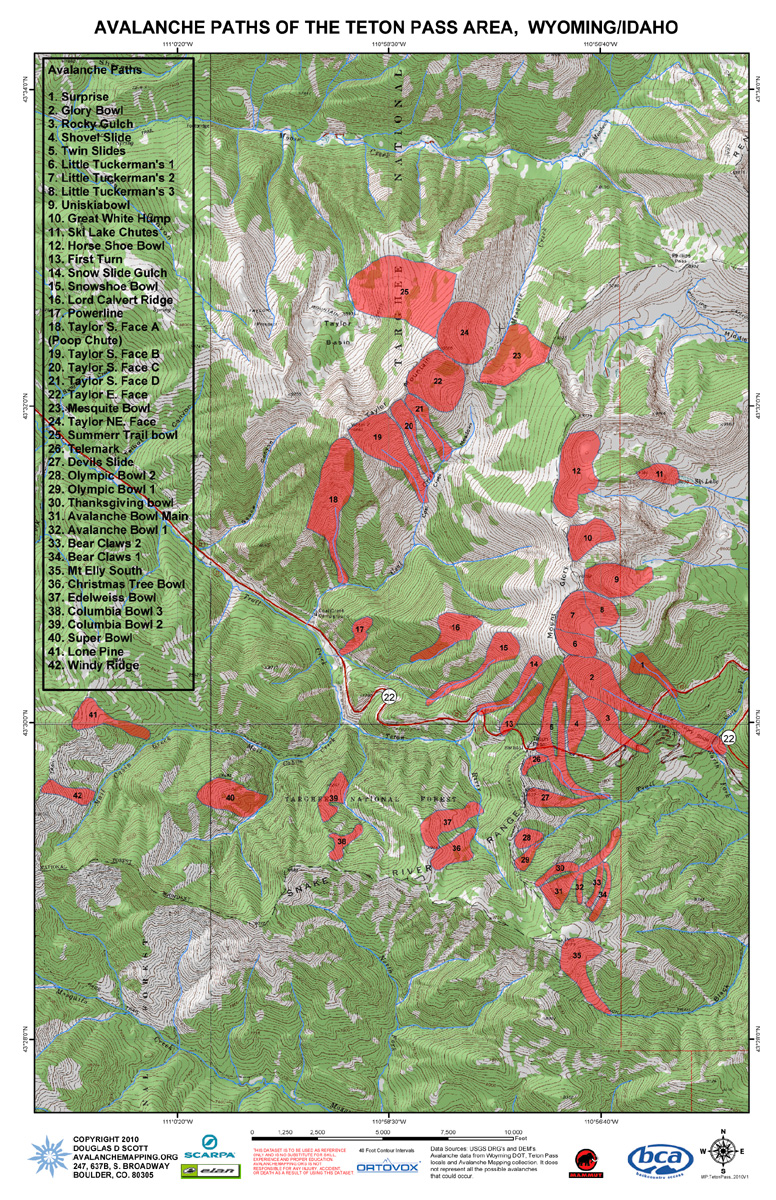
Avalanche Path Atlas Map of Teton Pass, Wyoming.
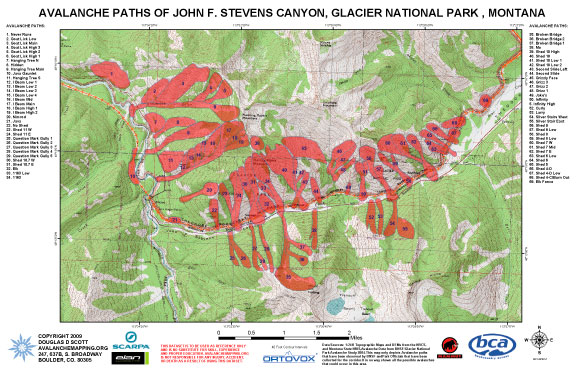
Avalanche Path Atlas Map of John F. Stevens Canyon,
Glacier National Park, Montana.
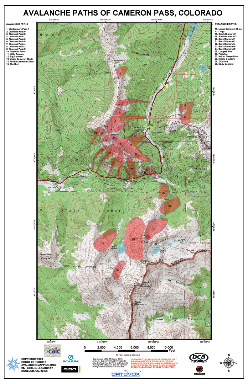
Avalanche Path Atlas Map of Cameron Pass, Colorado.
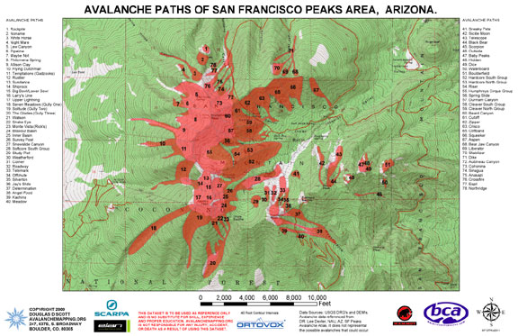
Avalanche Path Atlas Map of San Francisco Peaks,
Arizona.
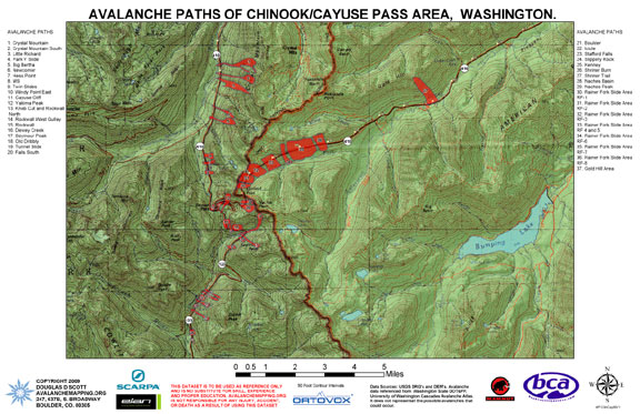
Avalanche Path Atlas Map of Chinook/Cayuse Pass,
Washington.
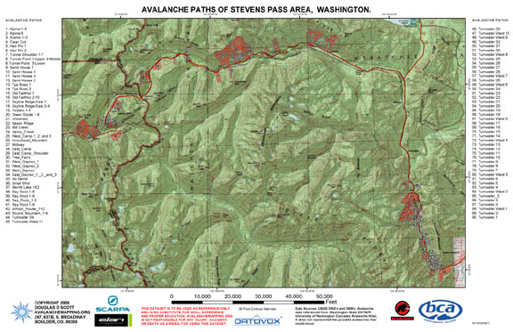
Avalanche Path Atlas Map of Stevens Pass, Washington.
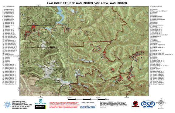
Avalanche Path Atlas Map of Washington Pass, Washington.
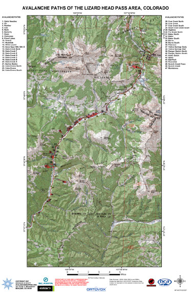
Avalanche Path Atlas Map
of Lizard Head Pass, Colorado.
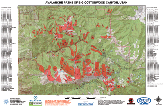
Avalanche Path Atlas Map
of Big Cottonwood Canyon, Utah.
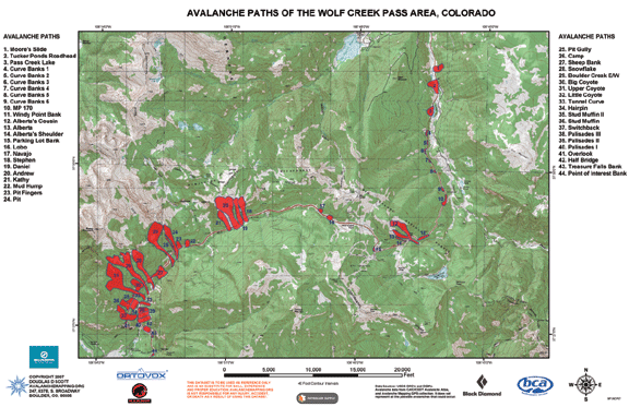
Avalanche Path Atlas Map
of Wolf Creek Pass, Colorado.
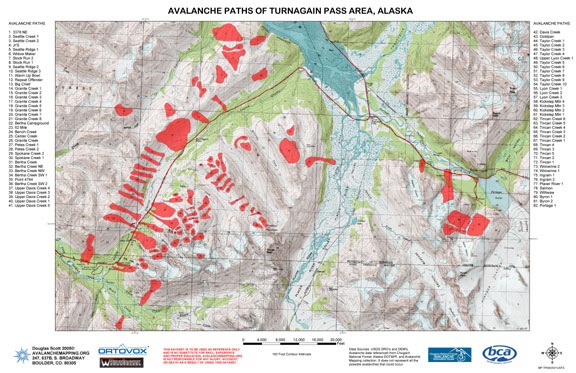
Avalanche Path Atlas Map of Turnagain Pass, Alaska.
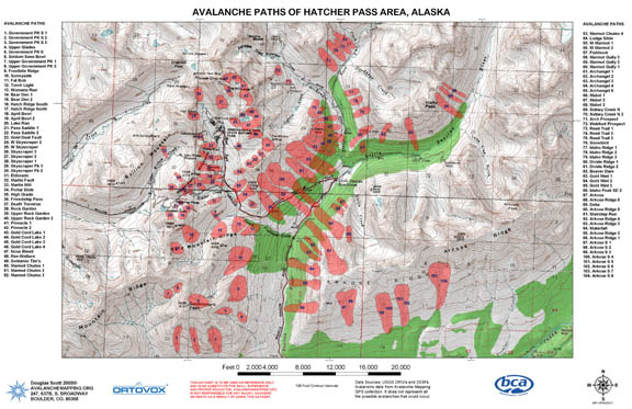
Avalanche Path Atlas Map of Hatcher Pass, Alaska.
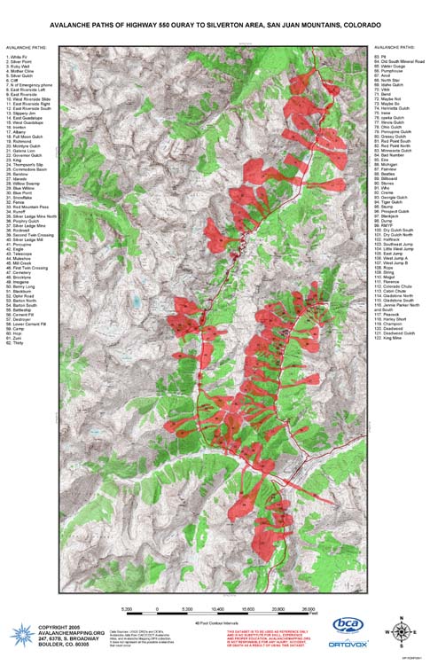
Avalanche Path Atlas Map of Red Mountain Pass,
Colorado.
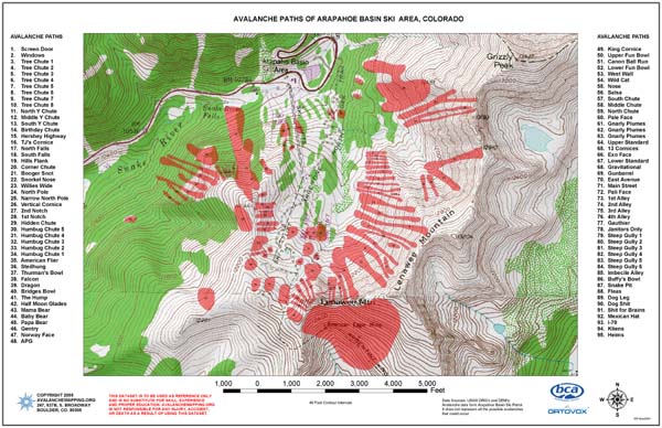
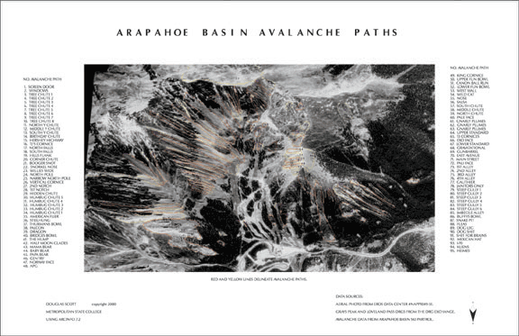
Avalanche Path Atlas Map of Arapahoe Basin Ski
Area, Colorado on a Topo Map.
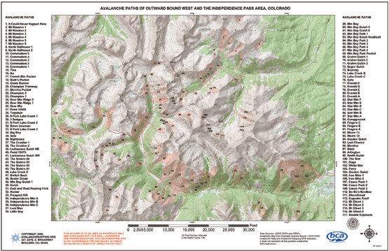
Avalanche Path Atlas Map of Independence Pass,
Colorado.
Avalanche Path Atlas Map of Berthoud Pass, Colorado.

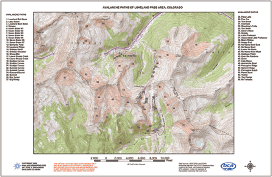
Avalanche Path Atlas Map of Loveland Pass, Colorado.
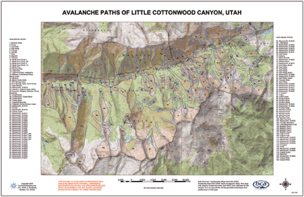
Avalanche Path Atlas Map of Little Cottonwood
Canyon, Utah.
Avalanche Path Atlas Map of Arapahoe Basin Ski
Area, Colorado.
Retail Outlets:
Mountain Outfitters, Breckenridge, Colorado.
http://www.mtnoutfitters.com/
Silverton Avalanche School, Silverton,
Colorado
http://www.avyschool.com/
Gear Exchange, Silverton, Colorado.
www.gear-exchange.com
Friends of Berthoud Pass, Denver, Colorado
http://berthoudpass.org/
Mountain Chalet, Colorado Springs, Colorado.
http://www.mtnchalet.com/
Neptune Mountaineering, Boulder, Colorado.
http://www.neptunemountaineering.com/
Boulder Map Gallery, Boulder, Colorado.
http://www.bouldermapgallery.com/
The Wilderness Exchange Unlimited, Denver, Colorado.
http://www.wildernessexchangeunlimited.com/
Bent Gate, Golden, Colorado.
http://www.bentgate.com/
Alpenglow Ski And Paddle Sports, Golden, Colorado.
http://www.alpenglowco.net
Pine Needle Mountaineering, Durango, Colorado.
http://www.pineneedle.com
Wilderness Sports, Frisco, Colorado, 970-668-8804.
Sawatch Backcountry, Leadville, Colorado, 719-486-2271.
Alaska Pacific University-Bookstore
The Map Store @ USGS
4230 University Dr. , Rm 101
Grace Hall, APU
Anchorage, AK. 99508
DISCLAIMER: THESE
MAPS ARE TO BE USED AS REFERENCE ONLY AND IS NO SUBSTITUTE FOR
SKILL, EXPERIENCE AND PROPER EDUCATION. SPATIAL ACCURACY OF THIS
TYPE OF DATA IS VARIABLE AND SNOW PROFILES CHANGE DAY TO DAY.
AVALANCHEMAPPING.ORG IS NOT RESPONSIBLE FOR ANY INJURY, ACCIDENT,
OR DEATH AS A RESULT OF USING THIS DATA. |