GPS AVALANCHE
AND SNOW PIT DATA COLLECTION. |
||
| SECTION
1 HOME PURPOSE and GENERAL INFORMATION SECTION 2 SECTION
3 |
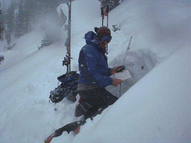
Matt Tomaszewski PHOTO DATA COLLECTION ON THE TOP OF THE 80'S, BERTHOUD PASS, COLORADO. Research and Developement: Data Collection for snow pits and avalanche paths development page. Collecting GPS and Snow Data: This is basically the addition to GPS coordinates to the avalanche or snow pit data you collect in your field book: For Snow pits: 1. Just collect and name a GPS waypoint at the pit after is has been dug and write down the field data in your pit profile book. 2. When you get back from the field download the data using the Garmin extension software, or if you have another GPS unit use the EasyGPS software, both are listed the software Downloads page. 3. Save the GPS data as a "Text" file from the GARMIN software or a "GPX" file from the "EasyGPS" software. 4. Fill out the data tables with the field information from your field book, these are available from the bottom of this page. 5. Email or upload the table files to be converted into a GIS file that can be displayed on a on a map and the data will be stored in database. Collecting GPS and Avalanche Data: For Slab Avalanches: 1. Collect the middle and the ends of the crown, then the maximum width ant the point of the toe, if the conditions allow it. 2. Record the snow data each point. 3. When you are back from the field download the data using the Garmin software extension, or if you have another GPS type use the "EasyGPS" software listed in the "Software Downloads" page. 4. Save the GPS data as a "Text" file from the Garmin Extension software or a "GPX" file from the "EasyGPS" software. 5. Fill out the data tables with the field data from your book, these are available on this page. For Point Release Avalanches: 1. Collect the start point, the ends and middle of the toe. 2. Record the snow data for each point. 3. Follow the directions listed above for reporting the data. TABLES: These tables were provided courtesy of Dave Ream and were presented at the 2000 ISSW Conference. copyright©2003 avalanchemapping.org |